
Visit Missouri’s “Little Grand Canyon” where you will find a true chasm, caves, a natural bridge, and picnic areas. Park managers have laid out trails and installed wheelchair-accessible boardwalks and overlooks at this 322-acre day-use park.

LOCAL OLD-TIMERS knew it all along. The stream of Grand Gulf canyon a few miles north of the Missouri-Arkansas line, which disappears into subterranean caverns, reemerges nine miles south as the famous Mammoth Spring that bursts from the earth in Arkansas. In 1941, folklorist Otto Rayburn reported a local experiment: people dumped sacks of oats into the stream in the canyon and then observed the oats emerge in the spring. Later investigators confirmed the experiment with fluorescein dye.
Although it had been considered as early as 1939, Missouri’s “Little Grand Canyon” in Oregon County was added to the state park system in 1984. It has a long history as a public attraction and a source of pride and wonder to nearby Ozark residents. The area is steeped in folklore and is a popular picnic and sparking area. Unlike the Grand Canyon, which is wider than it is deep, Grand Gulf is truly a chasm, deeper than it is wide.
Comparisons to the Grand Canyon aside, Grand Gulf is a striking landscape. To understand its story, one must turn to geologists for an explanation. It began, like the rest of the Ozarks, with the deposit of sediments that eventually formed limestones and dolomites, the uplifting of those layers, and the dissolving action of mildly acidic groundwater, which carved fissures and channels in the bedrock. Here at Grand Gulf is a cave system whose roof collapsed thousands of years ago. The result is a vertical-walled canyon about three-quarters of a mile long. Bussell Branch, a surface stream draining some twenty-eight square miles that once flowed above the cave system, became diverted into the chasm in a process geologists call stream piracy. Over the years, the gulf was further altered by the pour-off from the Bussell Branch watershed.
All of this water still today passes through a 250-foot natural tunnel—the part of the cave that remains intact—and emerges into a large circular chasm, another remnant of a collapsed cave chamber. Here the stream submerges back into the cave system and begins its Stygian journey toward rebirth in Mammoth Spring.
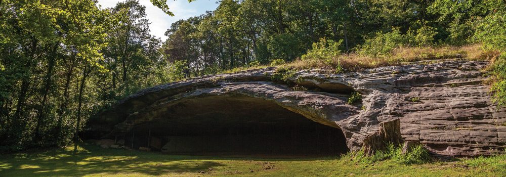
The walls of the canyon are festooned with herbaceous greenery and, in the lower sections, flood debris. These cliffs rise as much as 130 feet at the natural bridge.
The steep walls required explorers to make their way upstream for some distance to gain safe access. Then, walking downstream, they could enter the tunnel, which at ordinary water levels is some seventy-
five feet high. If they happened to notice that the flood debris had reached this same height, they’d have known to scan the sky for possible thunderheads before proceeding. The ceiling height drops to only about ten feet on the downstream end of the tunnel. Entering into the chasm and coursing past large blocks of dolomite—part of the collapsed roof—the stream reaches the extant portion of the cave, which acts as a drain for all the water flowing into the gulf.

Photo by Denise Vaughn
This passage from the chasm to the cave long fascinated scientists and spelunkers. How could so massive a cave system pinch out into such a small, unimpressive end? Fortunately and intriguingly, accounts by earlier explorers give us the answer. In her now classic Cave Regions of the Ozarks and Black Hills (1898), the young scientist Luella Agnes Owen recounted her exploration along with two companions. She described what they saw after entering the cave at the downstream end of the gulf and proceeding perhaps six hundred feet farther downstream: “The ceiling dipped so we were not able to stand straight, and the guide said he had never gone farther; but to his surprise here was a light boat,
which I am ready to admit, he displayed no eagerness to appropriate to his own use, and swimming about it, close to shore, were numerous small, eyeless fish, pure white and perfectly fearless; the first I had ever seen, and little beauties.”
Bravely, Luella determined to use the boat to explore the underground stream even further, leaving her nephew and the guide behind holding an attached coil of slender twine that would be her only lifeline to return against the current. Luella continued in the boat along a narrow, rocky, twisty channel until she came to an even smaller passage where she could lodge the boat sideways against the rocks and enjoy “an astonishing multitude” of the fearless eyeless fish. Then, acceding to the shouts of her guide that he feared the twine could be severed by the rocks, she let him pull her back.
The boat had apparently been left by an earlier exploration led by Maj. M. G. Norman, who owned the property surrounding the gulf. Access to the first part of the cave was available, according to local residents, until the early 1920s when a great storm filled the gulf with downed trees and other debris. Ever since, that stream and Luella Owen’s “little beauties” have remained unviewed. In the 1990s, state park officials employed a robot that toted a camera and digging tool to try to find a way past the flood debris and into the cave. They eventually gave up, deciding that any effort to break up the plug could risk havoc at Mammoth Spring and the adjacent town during floods.
Heavy rains can fill the entire gulf to depths exceeding one hundred feet. Several times in recent years, even the 130-foot-high observation platform has been covered. As the gulf begins to drain after a storm, waterfalls of seventy to eighty feet may be observed.

Photo by Lauren Stroer
In 1959, the Missouri General Assembly narrowly defeated a locally sponsored measure to allow the state to acquire Grand Gulf as a state park. But local interest in creating a park continued unabated. In 1970 St. Louis forest owner and conservationist Leo Drey purchased the land in order to assure its preservation. The following year, the US Department of the Interior designated the gulf as a National Natural Landmark, the first of Missouri’s sixteen natural landmarks to win this coveted distinction. And finally, in 1984 the land came into the state park system through a lease agreement between Drey’s L-A-D Foundation and the state, thus assuring its continued availability for public enjoyment and enlightenment.
Park managers have laid out trails and installed wheelchair-accessible boardwalks and overlooks at this 322-acre day-use park, so some sixty thousand visitors a year can get close to the edge of the gulf without endangering themselves or the environment.
A hike on the mile-long woodland trail surrounding the gulf reveals evidence of debris that has floated along the shorelines, indicating past high-water marks of this huge, temporary natural bathtub. The Spanish oak-dominated woodlands that surround the chasm are relatively dry, and park managers are treating them with prescribed fire to encourage the unusually interesting ground flora, providing visitors an opportunity to walk through a landscape rare in Missouri.
Outdoor exhibits at the trailhead provide artistic renderings of the geology, so visitors can visualize the processes that produced Missouri’s “Little Grand Canyon.”

GRAND GULF STATE PARK • ROUTE W, THAYER
“A lost river, born in Missouri, reborn in Arkansas,” is how folklorist Otto Rayburn described it in Ozark Country, 1941.
Order Missouri State Parks and Historic Site here.
Read about seven more state parks here.
Related Posts

A True Gem of a State Park
Dedicated in 1938, this gem of a state park now sits amid an expanding suburban landscape and is worthy of a visit any time of year. There are twenty-two CCC-era structures to visit, rocky hills to hike, and massive trees to stop and rest under.

Get Out and Enjoy the Katy Trail State Park!
What was once the MKT (Missouri-Kansas-Texas) railroad,The Katy Trail State Park has so much to explore on foot, by bike, or on some stretches, horseback. The trail runs 240 miles over 14 counties. Get out and see the state in a whole new way.
Hiking Graham Cave State Park
Head over to Graham Cave State Park to walk in the footsteps of early Missourians.